HIKING HAPPENINGS September 2011
Burro Pass – Gateway To The Tundra
article and photos by Marcy Hafner
According to one source, the word tundra, which is derived from the Lappish language, means “land of no trees.” In this top-of-the-world life zone of intense cold and fierce winds, only the slow growing, ground-clinging perennials can eke out an existence by using a “less is better” method – a strategy that reduces exposure to the harsh elements. Within the Colorado Plateau, the alpine tundra begins only at the higher altitudes and the La Sal Mountains have enough elevation above 11,500 feet to support this tenacious plant community. This summer conditions were perfect for an incredible explosion of tundra wildflowers – an event I didn’t want to miss.
Because there’s less air at high altitude, it takes effort to hike above timberline; one of the easiest and quickest routes for access is off Burro Pass via the Geyser Pass Road. To get to the Burro Pass Trailhead, drive south eight miles on Highway 191 out of Moab. Then, take the left hand turn to Ken’s Lake, go half a mile to the stop sign and take a right on Spanish Valley Drive, which turns into the La Sal Loop Road. Approximately twenty miles from town turn right at the sign for the Geyser Pass Road. Then, drive eight miles on a graveled road to the pass, which at 10,500 feet has nothing to do with a geyser. Instead, it is named after the early cattleman, Al Geyser.
The last few miles – after the turn off for Gold Basin - are narrow so be prepared to pull over or back up for oncoming vehicles. Not far beyond Geyser Pass, a sign marks a fork in the road – right to Dark Canyon Lake and Highway 46, left for Moonlight Meadows and Burro Pass. Drive 1.2 miles on the left fork and then look for the left turn to route 2040 – the sign for Burro Pass is missing. Four-wheel drive is highly recommended on this last half-mile section to the trailhead.
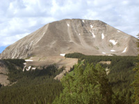  Before my hike, I pause to turn my attention south and gaze at the two highest peaks in the La Sals. Mount Peale ranks first at 12,721 feet and Mount Mellenthein comes in a close second at 12,645 feet. Way beyond those prominent peaks, the San Juan Mountains and Sleeping Ute Mountain in Colorado cast their snowy profiles against the gathering thunderheads. Before my hike, I pause to turn my attention south and gaze at the two highest peaks in the La Sals. Mount Peale ranks first at 12,721 feet and Mount Mellenthein comes in a close second at 12,645 feet. Way beyond those prominent peaks, the San Juan Mountains and Sleeping Ute Mountain in Colorado cast their snowy profiles against the gathering thunderheads.
From the trailhead, it is almost a mile to Burro Pass and 4.5 miles to Warner Lake. This is the starting point for the Whole Enchilada, a popular mountain bike trail which runs a 26.5 mile course to the Colorado River – a vertical drop of 7,000 feet.
My journey to the tundra is filled with many rewards along the way, and after a short stroll through the cooling shade of firs, spruce and aspens, I walk through a wealth of wildflowers. Broadcasting their bounty of sweet nectar, industrious bumblebees respond, managing to squeeze their plump bodies into even the smallest of the nodding bluebells.
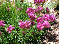
Fields of taller-than-me purplish-blue larkspur are pretty to look at but deadly to eat. All parts of this plant, which is in the buttercup family, contain toxic alkaloids and fatal poisonings occur – many of them among cattle.
The sneezeweed, which is similar in appearance to an overgrown yellow daisy, intrigues me with its odd name. The flowers when dried actually do make you sneeze, and Native Americans concocted a powdery snuff for the purpose of cleaning out the sinuses.
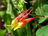
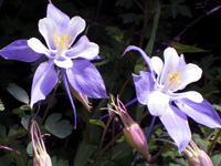
Gaining elevation, I am enchanted by a collection of blue columbine swaying in a slow breeze-tossed dance. To me, these exquisitely designed flowers of varying shades of blue and creamy white are symbolic of the high country.
With a view of Mount Tomasaki to my right and Manns Peak straight ahead, I forge on towards the pass and the tundra. On a talus slope a very vocal pika, blending in with his surroundings, sounds the alarm. If he’d kept his mouth shut, I would have been oblivious to his presence. It was his movements that gave him away so I could track him down! With his short rounded ears, he shows no resemblance to his rabbit and hare relatives. Instead, he reminds me of a brown guinea pig. Since they don’t hibernate through the winter, pikas gather their piles of “hay” during the summer to sustain them, and a pika in overdrive during harvest time is so entertaining to watch as he bounds from rock to rock with a bundle of grass dangling from his mouth.
 A short series of switchbacks swings me on to the open grassy slope of Burro Pass. At 11,180 feet, I have gained approximately 1,000 feet in elevation. Now, I constantly hear the sharp “krak” of Clark’s nutcrackers as I watch their black and white silhouettes along the ridgeline. Close relatives to jays, these birds, who prefer high elevations, have a pouch that holds up to 150 seeds which they bury in the ground for later consumption - the left-overs that are not consumed sometimes germinate into trees. A short series of switchbacks swings me on to the open grassy slope of Burro Pass. At 11,180 feet, I have gained approximately 1,000 feet in elevation. Now, I constantly hear the sharp “krak” of Clark’s nutcrackers as I watch their black and white silhouettes along the ridgeline. Close relatives to jays, these birds, who prefer high elevations, have a pouch that holds up to 150 seeds which they bury in the ground for later consumption - the left-overs that are not consumed sometimes germinate into trees.
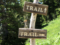 Arrows on a wooden post mark two separate trails. The arrow pointing straight ahead is for Warner Lake, and the right arrow for the Deep Creek Trail, which is the route that I am taking, is an artery for getting into the tundra and the top of Manns Peak. Arrows on a wooden post mark two separate trails. The arrow pointing straight ahead is for Warner Lake, and the right arrow for the Deep Creek Trail, which is the route that I am taking, is an artery for getting into the tundra and the top of Manns Peak.
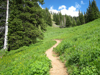
On the first short section, the sensation of walking on ball bearings is created as the loose gravel rolls around under my feet. It is a relief when the trail levels out! Traveling on this unmaintained path, which eventually wanders off into oblivion, trees that have fallen across it stay there - I either clamber over or skirt around them.
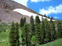
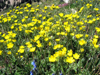
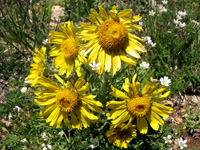
When the ridgeline between Manns and Tomasaki comes into view, it drops down and comes close to petering out. That’s my signal to head up, using Manns as my beacon, until the scattered stunted trees grow only in small thickets. Before long I leave all the trees behind and proceed into the wide-open tundra, where suddenly I am adrift in waves of yellow, blue, lavender, white and red flowers flaunting their bright colors. They are advertising to the pollinating insect world to come on up and sample the sweet bounty – a profusion of sky pilot, red clover, spring beauty, pussy toes, saxifrage, cinquefoil, owl clover and alpine sunflower, which is often called Old Man In The Mountain. Others are so tiny - I have to bend down to peer into the white blossoms of the moss-like alpine sandwort and the pink tubular flowers of the moss campion that are just fractions of an inch in size.
Marveling at how these plants can survive this harsh environment and still have enough energy to produce flowers, I can’t resist walking on and on and on to follow this wave of brilliant colors for as far as it goes. Knowing their fragility, I try hard to watch where I put my feet - a cluster of the pin cushion-like leaves of the moss campion can take up to 25 years to grow. A stroll to this high altitude literally takes my breath away, but being able to witness this stunning treasure is worth every deep breath and each slow step it took to get here.
|
Biological Soil Crust (aka)
Cryptos (krip’ tose):
The surface of
Moab’s desert is held
together by a thin skin of living organisms known as cryptobiotic
soil or cryptos. It has a lumpy black appearance, is very
fragile, and takes decades to heal when it has been damaged.
This soil is a critical part of the survival of the desert.
The cryptobiotic organisms help to stabilize the soil, hold
moisture, and provide protection for germination of the seeds
of other plants. Without it the dry areas of the west would
be much different. Although some disturbance is normal and
helps the soil to capture moisture, excessive disturbance
by hooves, bicycle tires and hiking boots has been shown
to destroy the cryptobiotic organisms and their contribution
to the soil. When you walk around Moab avoid crushing the
cryptos. Stay on trails, walk in washes, hop from stone to
stone. Whatever it takes, don’t crunch the cryptos
unless you absolutely have to! |

Cryptobiotic soil garden
|
|
|